


Chicago is a clumsy, skinny teenager of a city. Oh, you know what I'm talking about -- everybody knew that kid in high school who was well over 6'3" but barely weighed a buck thirty. He was always a little on awkward side -- he was super tall, yet he couldn't play basketball, he was friendly but not exactly suave, he was talented but would always rather not have attention called to himself. You knew that in good time he would fill out that skyscraper frame and all would be OK for our lanky friend... but he never really did. He just kept on living life in his oversized frame as if nothing was really wrong. Sure he's still a little awkward, but why should he worry about it? He has tons of character, he's quite cultured, and once you get to know him he's just as interesting as any of his larger, more popular friends. He's just skinny and tall.
And that's our fine city for you -- Chicago was built on a big city frame but has never fully fleshed out. Most of the density is located in the loop and vertically up and down the shoreline of Lake Michigan. Proof of our lanky frame can be seen in the low population density of many neighborhoods, such as in the East Village, where the entire neighborhood was zoned for bigger buildings, resulting in teardowns for new buildings that were never built. Or on the West Side, where clueless '60s era "urban renewal" razed entire blocks of buildings leaving empty lots in their place. Low population density is good for creating affordable property, but bad for creating urban neighborhoods, which -- according to New Urbanism ideals -- rely on density to keep a level of safety, massed resources, and continued vitality. But how do we create more density in a natural way -- through organic growth? The answer, my friends, lies in the El.
In a super dense urban-environment the most efficient way to get around is not hopping in the car -- it's catching a form of public transit. The El helps neighborhoods become vital by providing transportation infrastructure that is needed to support density. This is evident in Chicago on most of the North Side, the near northwest, and the near south where you find massive density grouped around the train lines. You can almost watch the growth (or gentrification) spread up the Blue Line from West Town out past Logan Square in real time.
The El is a neighborhood enabler -- an area's potential for growth and vitality is directly related its El stops. For an example of what I mean, check out Chicago's West Side, an area which is rough and ready for revitalization of its old neighborhoods (Garfield Park) and growth of underdeveloped neighborhoods (west of the United Center). In the '60s the city cleared acres and acres of land on the West Side in an attempt to create "something out of nothing." This act of urban renewal resulted in massive open tracts of land that have mostly sat un(der)used for the past 50 years. All of this open space is potentially "dangerous" -- if the wrong developers get their hands on acres of open space, we could be looking at a landscape of parking lots and big-box-stores, ala the North/Clybourn district or along Elston Ave. -- certainly not urban-minded development. You can't exactly take the train home from Costco. Additionally, old industrial buildings can find new leases on life in the post-industrial age by being converted into living spaces, offices, businesses, restaurants, community centers, libraries -- the possibilities are endless, and don't necessarily need to point to loft-condos. Preserving old buildings along with new construction is vital in preserving a sense of neighborhood authenticity and creating another great Chicago neighborhood. Chicago is ready to fill out its big city frame -- and the next place to work on is the long atrophying West Side. The CTA could be the enabler to make this happen. So what needs to happen?
The CTA needs to form a mass transit network -- as opposed to the current radial commuter rail. Right now, all lines lead to the Loop in the morning and back out in the afternoon -- these lines don't take into account that a lot of living happens outside of the skyscrapers of the Loop. What happens when I want to get from Bucktown to Wrigleyville? Andersonville to the West Loop? Hyde Park to Pilsen? Little Village to Logan Square? These rides are a pain in the ass -- they're slow, indirect, and require multiple bus transfers. Why can't you move from the North Side to the northWest Side without going downtown first? I want answers, dammit!
OK, here's one: a few years ago the CTA presented us a proposal for The Circle Line. (If you aren't already familiar with this conceptual plan, I recommend reading through Chicago-L.org's excellent section on this plan.) If built, the Circle Line would link all of Chicago's El lines (and all of the Metra lines) with only 6.6 miles of new or rebuilt El and subway tracks. Although the plan is actually quite complex, and involves rerouting many of the lines over time, the basic concept behind the Circle Line is quite simple -- it makes neighborhood-to-neighborhood trips a hell of a lot easier. Imagine -- no longer is it a requirement to route through downtown or take a bus when making the trip from UIC to Ukrainian Village, Lincoln Park to the United Center, or Brighton Park to West Pilsen. O, beautiful network!
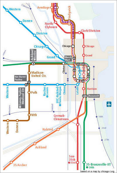
The first step of this massive project has already been completed -- the section of track that connects the Green Line (Ashland stop) to the Forest Park Blue Line (Medical Center) has already been rehabbed and is ready for train action. This addition of track will add a much-needed stop right next to the United Center, and will necessitate a transfer station at the current split between the two branches of the Blue Line, but other than that, it's ready to roll. Apparently routing the Blue Line up to the Green Line has sparked some controversy from some neighborhood groups based along the Cermak branch -- although I'm not entirely sure why -- the new plan allows them to get to any other train line much faster than before, and the only downside I can see is a necessity to transfer to the Blue Line if they want to take it to the Loop. (Although they could just as easily stay on the Cermak train to Clark/Lake and transfer to the Blue Line there.) This first phase of the Circle Line reroutes two of the train lines to help make use of the new track. The Brown Line is routed down to the South Side and into the former Cermak Blue Line branch -- thus eliminating the confusion of two separate Blue Line branches and allowing them to operate completely independently of each other. Additionally, the Orange Line is brought up to the North Side where it will share a track with the Brown Line.
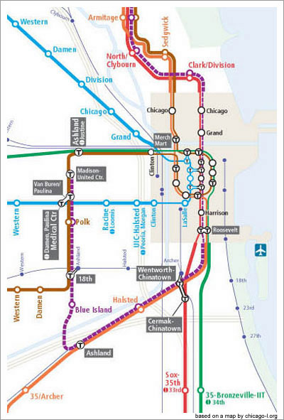
Step two is the Cermak-Archer Connector -- connecting the Cermak Blue Line branch (18th stop) to the Orange Line (Ashland stop) via elevated tracks. This stretch would be about 1.3 miles through a mostly industrial area and over the Stevenson (I-55) and the Sanitary & Ship Canal. This seems like an absolute no-brainer to me -- this is a short section of track, the highway is elevated here, so it could pass underneath, and a small bridge over the canal should be simple enough. This phase permanently routes the Purple Line through the Red Line subway, and temporarily down from the Loop via the Orange Line tracks, where it will then head north from Ashland to end at the United Center. This is meant as temporary solution while the remainder of the Circle line is completed. The only thing that perplexes me a little is why the CTA planners didn't attempt/propose a connection through Bridgeport, from Ashland to Sox-35th. This would most likely require a subway construction to preserve the aesthetic of the neighborhood, but it would also provide an El stop to central Bridgeport and ultimately could complete the entire outer Loop.
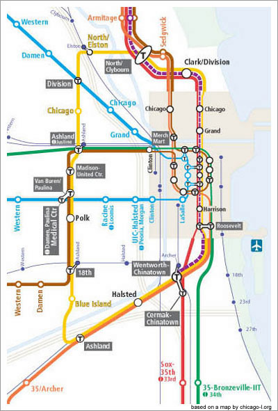
The final and most difficult phase is to create the North-Ashland Subway. This connects the Green Line (Ashland stop) to the O'Hare Blue Line (Division stop) to the Red Line (North/Clybourn stop). This triple-line link runs through dense neighborhoods (West Town, East Village, Noble Square, Wicker Park, North/Clybourn retail district), heavily traveled roads (North Ave., Ashland, I-90/94), and connects two existing subway stops and an elevated station. This will necessitate a new "Super Station" at North/Clybourn, where the Brown Line, Red Line, and Circle Line will all converge, not to mention a station rehab at Division/Milwaukee for transfer to the Circle Line and two brand new stations at Elston/North and Chicago/Ashland. Yikes! Better start digging. This section of the Circle Line would begin to physically link the northwest neighborhoods to the North Side neighborhoods, eliminating yet another unspoken neighborhood boundary. Currently there are multiple physical barriers that separate these two heavily populated areas -- the Chicago River, the Kennedy, train tracks, industrial districts -- making travel between them quite difficult. The North-Ashland Subway bridges this gap and would begin to blur the distinction between the North Side and the near northwest. This phase eliminates the additional Purple Line routing by creating a new train line, depicted below as the "Gold Line".
The Circle Line is an exciting beginning of a networked CTA -- suddenly the El is no longer a radial commuter rail, but a fully functional public transportation network that can be used for everyday life as well as commuting to the Loop. But what about many of the outlying neighborhoods; why are they still stranded? Why not push further out? Why not connect more of the lines? Why not push the El into areas that have relied on busses for too long? Why not allow Chicago to expand and fill out its massive frame? The future of our fine city depends on the development of the El -- the Circle Line may be decades ahead of us, but why stop there?
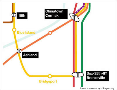
Let's complete the "Circle Line" by connecting the Orange, Red, and Green Lines on the South Side. This final spur would truly complete the Circle Line by running a subway from the Ashland Orange Line stop, down 35th street through Bridgeport, and terminating at a "Superstation" that would link the Circle Line to the 35th/Sox Red Line stop and the 35th/Bronzeville-IIT Green Line stop. The Circle Line would live up to its name and break the rapid transit boundary between the South and the Southwest Sides.
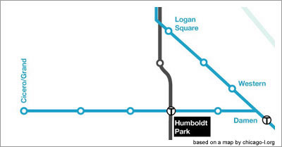
Let's bring back the Humboldt Park Line. This line used to spur off of the O'Hare Blue Line at Damen and paralleled North Avenue out past Kedzie to Lawndale, but CTA shut it down due to low ridership in the early '50s. The newer incarnation of the Humboldt Park line would follow the same path, but would terminate at North & Cicero, Close to Grand Ave. The Humboldt Park Line would fill in a massive gap in East-West El lines on Chicago's West Side and would enable growth in the Humboldt Park and Cragin neighborhoods.
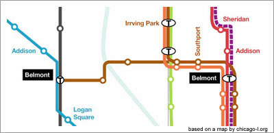
Let's connect the Brown Line to the Blue Line. A Roscoe Street Subway line would spur off the Brown Line in Roscoe Village, jog down to Belmont Ave. by the Chicago River, and would hook up to the Belmont Blue Line subway stop for transfer. This 2 mile link would bring rapid transit to Avondale and would also create another link between the North and Northwest neighborhoods. Additionally this would make transit to O'Hare that much quicker for far North Side residents.
Let's shoot another train line through the North Side that brings rapid transit to the underserved North-Central corridor. This line (We'll call it the North-Central Line) would originate at the Circle Line's North-Elston subway station and would follow the same path as the Metra lines between Elston Avenue and 90/94 until it straightens at Diversey and follows Ravenswood Ave. northward. At this point the line could be built as an elevated line above the current Metra tracks until it meets up with the current Brown Line tracks at Roscoe Ave. When the Brown Line turns west again at Wilson, the North-Central would continue over top of the Metra tracks northward until Granville, when it would head underground to become a subway line beneath Ridge Ave. The North-Central Line subway would continue northwest underneath Ridge for 2 miles, finally meeting up with the Yellow Line in Evanston at a "reincarnated" Asbury stop (which was closed in 1948). This North-Central El line would bring rapid transit to some densely populated residential areas in the city in West Lakeview, North Center and Andersonville as well as begin to pull some vitality further West into Bryn Mawr and West Rogers Park.

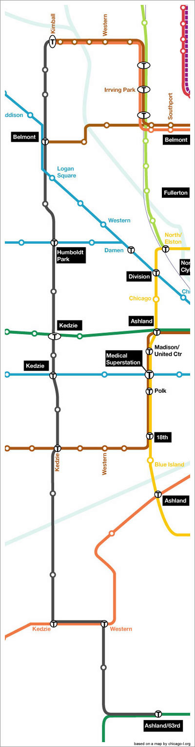
Let's create a Kedzie Avenue Subway line. This line would become the "Red Line of the West" by stretching 15 miles down the West Side and would link all of the east-west El lines in the city. The Kedzie Avenue Subway would begin at the Kimball Brown Line stop, link to the O'Hare Blue Line at the Belmont "Superstation" (Blue Line + Roscoe St. Subway + Kedzie Ave. Subway), link to the new Humboldt Park Line, Green Line, both branches of the southern Blue Line, then would jog under the Stevenson to meet up with the Orange Line, and would join the Ashland branch of the Green Line west of Washington Park. This massive outer loop would add a third tier to the Circle Line concept and would help link the massive population growth that the far neighborhoods will experience once the near neighborhoods have reached their maximum capacities.
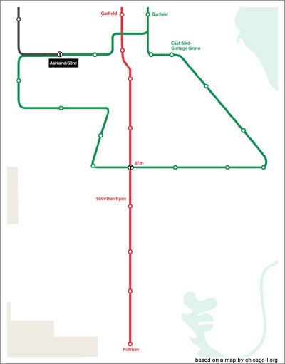
Let's interconnect the far South Side. The Red Line would simply be extended to Pullman, but the East 63rd branch of the Green Line would wrap down by the South Shore, link at 95th to the Red Line, and would connect back to the Ashland Green Line and proposed Kedzie St. Subway. This large loop would help further the process of regenerating the far South Side and become an enabler for organic neighborhood growth.
And there you have it -- your CTA Map for the year 2055. Here's a handy PDF of the whole map. It's certainly not flawless, but it's not about right or wrong -- it's about constructive ideation on our built environment. Chicago is a world-class city that's ready to lead the world through the 21st Century, and now is the time to start thinking about how we can strengthen our city. It's time for lanky Chicago to fill into its broad shoulders we all talk about. Will we let our neighborhoods become monotonous car-dependent urban sprawl with no discernible difference between city and suburb? Or will we let the great enabler -- the El -- help us create a dynamic network of urban neighborhoods full of character, vitality, and life?
Special thanks to Chicago-L.org for its conceptual maps of the Circle Line.
